

Loading panorama viewer ...
Configuring ...
© 2010 Ken Stuart, All Rights Reserved.
Caption
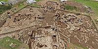
Nearing the end of its sixth season of excavation, the Neolithic site known as the Ness of Brodgar raises more questions than it answers.It seems that some 5,000 years ago, people deliberately tore down these structures, which had been constructed and re-constructed over many years.
Located at the heart of Neolithic Orkney, the Ness structures nestle amongst numerous ancient monuments: stone rings, standing stones, settlements, tombs, graves, etc. Little survives besides stones and bones, but as apparent in this panorama, those remains can be spectacular.
Learn more about the site and the project, Orkneyjar - The Ness of Brodgar Excavations, at its web site. Stop by to visit in-person if you find yourself in the neighborhood: it's worth the time!
Location
Lat: 58° 59' 51.01" N
Long: 4° 13' 53.41" W
Precision is: Medium. Nearby, but not to the last decimal.
Equipment
Nikon D70, handheld underneath the basket of a cherry picker (hydraulic boom lift); PTGui Pro, Photoshop, Pano2VR.
 Tap or click the zoom icon in the bottom right corner of the picture to switch between in-page and fullscreen view