
The Coin is Up ...
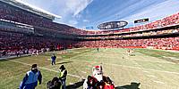
Arrowhead Stadium, Kansas City, Missouri, USA
December 5, 2010, 12:01:12 pm CST (18:01:12 UT)

Loading panorama viewer ...
Configuring ...
© 2010 Pat Swovelin, All Rights Reserved.
Caption
Denver won the toss and elected to receive but it did them no good and the Chiefs went on to win it 10-6.4 shots. 6 seconds. Be quick because it's over before you know it's even started. Trust me on that one.
Location
Lat: 39° 2' 56.17" N
Long: 95° 30' 2.34" W
Elevation: 842 feet + 8 feet to be over their heads
Precision is: High. Pinpoints the exact spot.
Equipment
Canon EOS 450D (Digital Rebel XSi), Sigma 8mm F3.5 EX DG Circular Fisheye lens, Nodal Ninja R-1 panohead, custom-made pano pole, Yong Nuo YN-128 wireless remote control, ISO 200, f8, 1/250 second exposure, Adobe Bridge CS5, Adobe Camera Raw 6.3.0.79, Adobe Photoshop CS5 Extended, PTGui Pro 9.0.1, Pano2VR 3.0 beta3, NBNC, PDL
 Tap or click the zoom icon in the bottom right corner of the picture to switch between in-page and fullscreen view