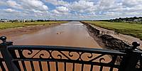

Petitcodiac River and Tidal Bore
Moncton, New Brunswick, Canada
August 25, 2010, 11:35 am local time

Loading panorama viewer ...
Configuring ...
© 2010 Jean Berthélémé, All Rights Reserved.
Caption
Petitcodiac River and Tidal Bore
The Petitcodiac River is situated in the province of New Brunswick, Canada. It is one of only a few rivers in the world that feature a tidal bore. This natural phenomenon is caused by the tides of the Bay of Fundy, some of the highest in the world. A tidal bore is a wave formed by the rising tide, which goes against the normal flow of a river.The tidal bore actually causes the flow of the Petitcodiac River to reverse direction twice daily as the tide comes up the funnel-shaped Bay of Fundy and overpowers the normal outgoing flow of the river.
This 360-degree interactive panoramic image of the Petitcodiac River and its tidal bore was created from pictures taken from the Gunningsville Bridge; it links the city of Moncton and the town of Riverview. The bridge was built as a replacement in 2005; one of the previous bridge's piers can still be seen downstream, in front of the incoming tidal bore.
Don't leave this page until you see the image in full-screen mode!
For more information about the Petitcodiac River, visit The Petitcodiac Riverkeeper website.
Rivière Petitcodiac et son mascaret
La rivière Petitcodiac est située dans la province du Nouveau-Brunswick, au Canada. Il s'agit de l'une des rares rivières au monde qui comporte un mascaret. Ce phénomène naturel est causé par les marées de la Baie de Fundy, qui sont parmi les plus hautes au monde. Un mascaret est une vague causé par la marée montante, celle-ci va à l'encontre du courant normal d'un cours d'eau.Le mascaret a pour effet de renverser la direction du courant de la rivière deux fois par jour alors qu'il remonte celle-ci, en provenance de la Baie de Fundy. La baie est en forme d'entonnoir, ce qui explique en partie la puissance de ses marées.
Cette image panoramique interactive à 360 degrés de la rivière Petitcodiac et du mascaret a été produite à partir de photos prises du pont de Gunningsville; celui-ci relie la ville de Moncton et le village de Riverview. Le pont a été construit en 2005 en remplacement d'un plus ancien pont dont on voit encore la base d'un pilier au milieu de la rivière, devant le mascaret qui s'approche.
Ne quittez pas cette page sans avoir vu l'image en mode plein-écran!
Pour plus d'information au sujet de la rivière Petitcodiac, visitez le site web des Sentinelles Petitcodiac.
Location
USA-Canada / Canada-New Brunswick
Lat: 46° 4' 26.4" N
Long: 65° 48' 1.68" W
Precision is: Medium. Nearby, but not to the last decimal.
Equipment
Camera: Nikon D300s. Lens: Sigma 8 mm fish-eye. The view is a full spherical panoramic image: 360 x 180 degrees. The image is composed of 7,000 x 3,500 pixels (it appears in a 570 x 320 window on this page). The JPG file size is approximately 3.6 MB.
 Tap or click the zoom icon in the bottom right corner of the picture to switch between in-page and fullscreen view