
Visible Effects of the Climate Changes
Aletsch Glacier, Switzerland
August 21, 2010, 4:15 pm local time

Loading panorama viewer ...
Configuring ...
© 2010 Claudia Betschart,
Some Rights Reserved.

Caption
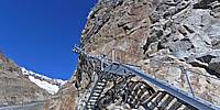
Best pano of 2010? Well, at least one of the few I had time to stitch this year...It was a gorgeous weekend in August when I participated in a glacier hike from the Jungfraujoch to the Konkordia hut and the next day on to the Fiescheralp.
The first Konkordia hut was constructed in 1877. At that time it was just 50m above the Aletsch Glacier. In the meantime the glacier melted so much that the place is now 150m above the glacier, above this high rock cliff. The route to the hut was changed a few times until finally these iron stairs were constructed in the early 1990s. They need to be extended every few years as the glacier continues to melt away at about 0.6 m/year.
Location
Lat: 46° 30' 2.73" N
Long: 8° 3' 7.01" E
Elevation: 2735 m
Precision is: High. Pinpoints the exact spot.
Equipment
Hardware: Nikon D5000, Sigma 8mm f4 D EX fisheye lens, handheld (using a "philopod")
Software: PTGui, Adobe Photoshop CS2
 Tap or click the zoom icon in the bottom right corner of the picture to switch between in-page and fullscreen view