

Loading panorama viewer ...
Configuring ...
© 2009 Paul Stewart, All Rights Reserved.
Caption
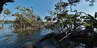
The Tatai River's source is in the beautiful Cardamom Mountain range. This and surrounding estuaries are currently being dredged of fine sand for Singapore's land reclamation and building works following a ban on the sale of sand by Indonesia.Numbers are hard to come by but estimates of between 7,000 and as much as 15,000 tons are being shipped out weekly. It's a huge operation.
The environmental impact on this is unknown and these delicate biodiversity incubators could be under a great deal of stress in the near future.
This could result in a catastrophic decline in shellfish nurseries. Uncontrollable erosion caused by a change in the hydrology of the estuary could damage or even destroy the coastal mangroves.
Where the tide meets the stream, these mangroves, Cambodia's primary coastal defenses, resist the forces of nature in a spectacular, chaotic and occasionally surreal expression of being on the edge of one world and the beginning of another.
Of being above water or below it.
Location
Lat: 11° 28' 14.85" N
Long: 103° 6' 56.14" E
Elevation: 0
Precision is: High. Pinpoints the exact spot.
Equipment
Nikon D70s + Nikkor 10.5mm + 360 Precision Absolute.
 Tap or click the zoom icon in the bottom right corner of the picture to switch between in-page and fullscreen view