
Ruined House at Cashelnagor
Cashelnagor, West Donegal, Ireland
8th September 2014 15:30 GMT

Loading panorama viewer ...
Configuring ...
© 2014 George Row, All Rights Reserved.
Caption
Cashelnagor - in Irish "Caiseal na gCorr" - literally means "Stone Fort of the Cranes" (or Herons). Cashelnagor is a townland in the Donegal Gaeltacht - the Irish speaking part of Ireland's rugged, windswept northwestern county.It's a small area that nestles between the Derryveagh mountains and the more populated strip along the Atlantic coast. It was made famous by the poetry of Cathal O Searcaigh. He is a member of Irelands Council of Artists: The Aosdana.
The Derryveagh mountain chain consists of seven peaks including Muckish, the Aghlas and Errigal. At 750m Errigal is the highest mountain in County Donegal. The mountain chain can be seen peeping over the nearby hillside. The cone-shaped peak of Mount Errigal can be seen on the right.
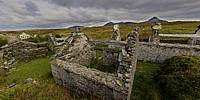
The 1911 census lists hundreds of households in Cashelnagor. Now there are a scattering of houses, most of them empty. There are many ruins. This is a particularly fine example.
This house was built in a dip, to shelter from the wind that blows in from the sea across the peat bog. It also has a high L-shaped stone wall behind and along one side, to provide more shelter.
During the famine years of the 1840s, a lot of people were lost from the landscape here, through death, evictions and emigration. In many cases their houses, built of timber mud and thatch, just rotted into the ground leaving very little trace.
Kevin Whelan (a geographer from University College Dublin) described it like this: "The ‘lie of the landscape’ is what it does not retain: the modern Irish landscape conceals the disappearance of three million people, especially those who lived in the clachans and the cottiers’ mud wall cabins. The Famine deaths - over one million - represent an absolute loss that is beyond redemption, a loss that theory cannot penetrate, that ethics cannot redeem. These spaces of the disappeared created negative landscape, marked by the presence of absence."
This ruined house had a slate roof and was built of flat quarried stone. The Derry to Dungloe railway line ran right past the yard around the house. A few hundred metres back up the track are the remains of Cashelnagor Railway station. This house was built of the same stone as was used to build the walls and embankments around the railway line.
So I guess that the house was built sometime after the famine after 1850 when the railway line was opened. The last train ran through here in 1952. There is evidence that in its later years the house had electricity. So it was certainly lived in during the early part of the twentieth century.
The other houses visible on the edge of the panorama are a whitewashed cottage built in the early part of the twentieth century, now also abandoned and a modern bungalow completed in the last ten years that has never been occupied.
Cathal O'Searcaigh's poem called "Anseo ag Staisiun Chaiseal Na gCorr" in English: "Here at Caiseal na gCorr Station." is the sound track to this panorama. While it is named for the station the poem talks of the whole local landscape and of O'Searcaigh's sense of place.
The poem was featured in a BBC Schools programme: Irish Poetry - A sense of Place and was also the backbone of a photography study of the area, also called Caiseal na gCorr.
Cathal O’Searcaigh’s books are available in the Apple iBook Store via kindle and no doubt in your local bookshop.
My print on demand service has Photographic prints of Cashelnagor.
I have also made this and other Photographs of Donegal available as:
I have also made this and other Photographs of Donegal available as:
- Poster prints of Donegal and even
- Phone covers, iPad cases and shopping bags of Donegal photographs
Location
Lat: 55° 4' 38.3" N
Long: 9° 8' 18.9" W
Elevation: 75m
Precision is: High. Pinpoints the exact spot.
Equipment
The source images were taken with a Canon EOS 5D Mk II, Canon EF 15mm f/2.8 Fisheye lens. The camera was mounted on a Kaiden Kiwi panorama adapter on a Manfrotto 190XDB tripod.
Horizontal photographs were taken at 60° angles and also two ground shots and a sky shot. Each "shot" consisted of three bracketed exposures from +2 to -2 stops.
A total of 27 separate images were combined using Hugin (which in turn invokes Nona, Enfuse and Enblend) in order to achieve this High Dynamic Range type result and to accommodate the moving vehicles.
 Tap or click the zoom icon in the bottom right corner of the picture to switch between in-page and fullscreen view