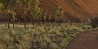

Uluru (Ayers Rock) Southern Face
Uluru - Kata Tjuta National Park, Northern Territory, Australia
28th November 2007, 5:50am (local)

© 2007 Aaron Spence, All Rights Reserved.
The traditional owners of this place ask that visitors don't climb the rock, but it is not their way to forbid it. Nevertheless as the climb is a strenuous undertaking, on days when the temperature is forecast to reach 36° degrees Celsius (97° Fahrenheit) the climb is closed at 8am.
I chose not to climb the rock, but instead did the 10km (6.5 mile) walk around the base of Uluru. I've not done the climb (apart from the first 50m when I was 4yrs old) but I imagine there is much more to see of Uluru walking around the rock rather than up it.
50km from here lies Kata Tjuta (The Olgas) another amazing place to visit. Kata Tjuta is much larger than Uluru, but composed of many rocks. You can see my Kata Tjuta virtual tours linked below.
This is the WWP 'Best Of' for 2007 and I have shot over 1500 panos this year which makes it difficult to choose...my 2nd choice was this virtual tour of Sydney Harbour Bridge, Opera House & Luna Park: http://www.panedia.com/map?mt=s&pano=2145
Kata Tjuta Virtual Tours: http://www.panedia.com/map?lat=-25.299182&lng=130.728893&zoom=1&mt=s
Kings Canyon Virtual Tours: http://www.panedia.com/map?lat=-24.250838&lng=131.573467&zoom=2&mt=t
Rainbow Valley Virtual Tours: http://www.panedia.com/map?lat=-24.333177&lng=133.635035&zoom=0&mt=s
Outback Australia Virtual Tours: http://www.panedia.com/map?lat=-24.347097&lng=132.912598&zoom=9
Australia - New Zealand / Australia
Lat: 26° 22' 8.4" S
Long: 131° 2' 4.8" E
Elevation: 519m/1702ft
Precision is: High. Pinpoints the exact spot.
 Tap or click the zoom icon in the bottom right corner of the picture to switch between in-page and fullscreen view