

Loading panorama viewer ...
Configuring ...
© 2011 Yoshiyuki Kaneko, All Rights Reserved.
Caption
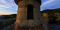
Oma Port was constructed during the Meiji period, 1868-1911, to facilitate the shipment of ores and materials used in mining.During the early 20th Century, Oma Port was continually updated through the addition of new facilities such as crane pedestals and loader piers.
Most of the port facilities have been demolished but one can still see vestiges of the port from its heyday in the remaining pedestals and embankment constructed.
The Oma port in 1935 is here.
Equipment
Canon30D + Sigma 8mm
PTGui Pro + Pano2VR + Photoshop
 Tap or click the zoom icon in the bottom right corner of the picture to switch between in-page and fullscreen view