

Loading panorama viewer ...
Configuring ...
© 2011 William M. Delabarre, All Rights Reserved.
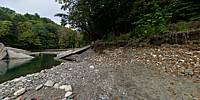
Caption
Hurricane Irene broke the pumping station dam and washed out the road to The Eunice Williams Covered Bridge.
Location
USA-Canada / USA-Massachusetts
Lat: 42° 38' 48.3" N
Long: 73° 38' 11.46" W
Elevation: 233
Precision is: High. Pinpoints the exact spot.
Equipment
Nikon d7000, Nikon 10.5mm lens
 Tap or click the zoom icon in the bottom right corner of the picture to switch between in-page and fullscreen view