

Loading panorama viewer ...
Configuring ...
© 2011 Uri Cogan, All Rights Reserved.
Caption
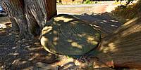
This ancient petroglyph of a seal is located in Drummond Park, Fulford Harbour, Salt Spring Island, BC.Salt Spring Island, also known as Klaathem (Quw'utsun word for Salt), was inhabited and used from time immemorial by the Malahat, Snuneymuxw, Tsawout, Tsartlip, Tseycum, Penelakut, and Quw'utsun First Nations who traditionally frequented the island's shores to harvest its natural resources.
Location
USA-Canada / Canada-British Columbia
Lat: 48° 46' 10.56" N
Long: 124° 28' 39.24" W
Elevation: 2
Precision is: High. Pinpoints the exact spot.
Equipment
Hardware: Nikon D700 with a 'shaved' Nikkor 10.5mm fisheye lens, Giotto tripod, Nodal Ninja pano head.Software: PTGui Pro, Pano2VR, Adobe Photoshop, Photomatix Pro.
This is an HDR image, processed in Photomatix Pro, 5 exposures.
Final panorama on my web site, in Flash and HTML5/CSS3 was done in KRpano.
 Tap or click the zoom icon in the bottom right corner of the picture to switch between in-page and fullscreen view