

Loading panorama viewer ...
Configuring ...
© 2011 Steve Nilsen,
Some Rights Reserved.

Caption
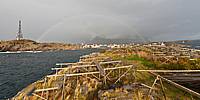
The day this picture was taken, the 25th of September, the weather showed itself from the wild side. Strong wind from north, rain, overcast clouds with the Sun showing up. This made the rainbow showing the pretty colours over the Henningsvær village for a few minutes. To bad the fog hangs in the mountain covering up the ruff terrain. History:
From the mid 1800s, Henningsvær consolidated its position as the most important fishing village in Lofoten. Previously, ownership of the village had changed hands a number of times, and it was not until squire Henrik Dreyer took over that developments really began to escalate.
Dreyer bought Henningsvær "with its 13 houses, 79 fisherman’s "rorbu" cabins and accompanying fish racks" for 6,000 spesidaler in 1842. In just a few years, he developed the village into a flourishing centre of trade and fisheries. An infirmary was established there with a resident doctor, together with a chapel and a lighthouse, and Dreyer has been given much of the credit for the fact that North Norway’s first telegraph line was established in Lofoten.
Dreyer was not unfamiliar with the idea of involving overseas capital in business ventures, and Skata and Sauøya, the north-eastern parts of Henningsvær, were sold, gradually ending up in the hands of English owners.
Many meagre years were to follow, with failing fisheries and a poor local economy. It was not until 1920 that the cod returned in abundance, paving the way for a new period of prosperity in Lofoten. And Henningsvær began to flourish again too, with the establishment of a number of new businesses. The year 1922 saw the advent of electric power in the village, and water supplies from the mainland were established a few years later.
Equipment
Canon 5D Mk II
Samyang 8mm
Agnos mRotater pole
 Tap or click the zoom icon in the bottom right corner of the picture to switch between in-page and fullscreen view