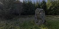

Loudon Wood Stone Circle
near Mintlaw, Aberdeenshire, Scotland, UK
September 25, 2011, 16.00 GMT

Loading panorama viewer ...
Configuring ...
© 2011 Robin Wilson, All Rights Reserved.
Caption
Dating from around the Neolithic age this Recumbent Stone Circle in Loudon Wood is one of the more difficult stone circles in Aberdeenshire to find as it is fairly well hidden in a forest of fir trees. The Recumbent Stone Circle is Aberdeenshire's unique contribution to the tradition of erecting rings of standing stones which was current in certain parts of Britain and Ireland during the third and second millennia BC. Up to 99 examples have been recorded, with diameters ranging from 18.2 m to 24.4 m. The distinctive feature of the Recumbent Stone Circle is the massive slab, laid recumbent on its side in the south-western or southern arc of the ring, and flanked by the two tallest stones of the circle. The recumbents average 24 tons in weight and were carefully levered and chocked-up to ensure that their upper surface was as level as possible.
The remains of this stone circle consists of four stones, including recumbent and its West flanker still standing in situ; three others fallen. The stones are set upon a bank 18.5m in diameter from crest to crest and about 0.8m above the interior. These remains of the circle indicate a diameter of about 19.5m.
Equipment
Canon 350D with Sigma 8mm. Stitched with: PTMac
 Tap or click the zoom icon in the bottom right corner of the picture to switch between in-page and fullscreen view