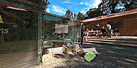

NEW HUT, ORIGINAL HUT
Orogorongo Valley, Wellington, Aotearoa/New Zealand
September 17, 2011, 2.55 pm NZST

Loading panorama viewer ...
Configuring ...
© 2011 Michael Bajko,
Some Rights Reserved.

Caption
This was the opening of a new Hut by the Dept. of Conservation in the Orongorongo Valley, Rimutaka Forest Park, east of Wellington. This Hut was built on the site of the original Hut built 1967-68 by myself and my mates in the Khandallah Venturer Unit (Senior Scouts). We had a reunion in February to take a last look at our handy work before the new hut was completed and our original demolished. This was when I shot the original. Google Earth presently shows the cleared site with our hut still intact.This new hut sleeps 30 while ours had a comfort limit of 10.
The Khandallah Scout Group came to an arrangement with D.O.C. where they gave up the lease on the site in exchange for a guaranteed number of nights that Group members can stay. A good deal as Scouting isn't as ebullient as in our day and maintenance costs never go away.
For a more in depth history please visit KVU '68. Be warned....teenagers will be teenagers!
Location
Australia - New Zealand / New Zealand
Lat: 42° 21' 7.3" S
Long: 174° 59' 2.87" E
Elevation: 138meters
Precision is: Unknown / Undeclared.
Equipment
Nikon D90, Nikkor 10.5mm, Panosaurus, Slik Tripod.
PC core2, XP Pro, Adobe Bridge, PTGui Pro 9.1 beta3, Photoshop CS5 Extended
 Tap or click the zoom icon in the bottom right corner of the picture to switch between in-page and fullscreen view