WWP Home arrow right This Event arrow right Indices: Alphabetical | Regional | Thumbnail | Map previousPrevious | Nextnext
event title
Europe
portrait Martin Hrdlička
History from Above
Česká Kamenice, Northern Bohemia
mini manual
[?]
Copyright © 2011 Martin Hrdlička, All Rights Reserved
VirtualPanorama.cz
Previous panorama: Don HofsteefullscreenA-Z Regions ThumbnlsShow in MapNext panorama: Edward Huff

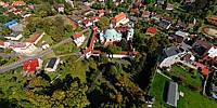
Panorama above the historic centre of Ceska Kamenice. Below is the beautiful Chapel of the Blessed Virgin Mary.

Location Map Geographic Coordinates:
Latitude: 50° 48' 7" N
Longitude: 14° 24' 55" E
Elevation: 100
arrow Show at MultiMap.com [what is MultiMap?]
arrow Show at Google Maps [what is Google Maps?]
arrow Show in Google Earth* [what is Google Earth?]
* requires Google Earth
installed on your computer

Date/Time:
September 25, 2011

Equipment:
Nikon + Octocopter, height 133m


http://www.virtualczech.cz http://www.virtualpanorama.cz

http://virtualniceskokamenicko.cz

text
WWP Home arrow right This Event arrow right Indices: Alphabetical | Regional | Thumbnail | Map previousPrevious | Nextnext