
Site of the First Transatlantic Wireless Signal
Signal Hill, St. John's, Newfoundland, Canada
September 22, 2011, 15:30 UTC

Loading panorama viewer ...
Configuring ...
© 2011 Kenneth A. Butt, All Rights Reserved.
Caption
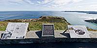
An important date in history; Guglielmo Marconi and his assistant, George Kemp, confirmed the reception of the first transatlantic wireless signals at this site, on December 12, 1901. The site overlooks the historic city of St. John's, Newfoundland, Canada and the most easterly point of land in North America, Cape Spear.
www.q-linear.com
Location
USA-Canada / Canada-Newfoundland and Labrador
Lat: 47° 34' 14.2" N
Long: 53° 41' 50.94" W
Precision is: Unknown / Undeclared.
Equipment
Pentax K-5
Pentax 10-17mm Fisheye
Manfrotto 190XProB with Ball Head
PTGui Pro
Photoshop CS4 Extended
 Tap or click the zoom icon in the bottom right corner of the picture to switch between in-page and fullscreen view