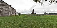

Henry Hill, Bull Run Battlefield
Bull Run Battlefield Park, Manassas, Virginia, USA
September 25, 2011 18:19 UTC (1:19 EST)

Loading panorama viewer ...
Configuring ...
© 2011 K. Wayne Heil, All Rights Reserved.
Caption
The First Battle of Bull Run was the first major battle of the American Civil War and took place over 100 years ago on July 21, 1861. The house that stood on the battlefield at that time belonged to Mrs. Judith Carter Henry, an 85-year-old widow, and her two sons. Mrs. Henry refused to leave her house before the battle and was mortally wounded by cannon fire during the battle, becoming the first civilian casualty of the war. Confederate soldiers buried her a few yards west of her home. Her grave stone, flanked by those of a son and daughter, can be seen in the panorama.
Location
Lat: 38° 48' 52.82" N
Long: 78° 32' 21.35" W
Elevation: 271
Precision is: Unknown / Undeclared.
Equipment
Nikon D300, Nikkor 8mm f2.8, Agnos panorama bracket, Gitzo monopod.Photoshop 5.1, PTGui Pro 9.1beta3, Pano2VR 64-bit.
 Tap or click the zoom icon in the bottom right corner of the picture to switch between in-page and fullscreen view