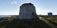

Carleton Martello Tower
Saint John, New Brunswick, Canada
September 17, 2011, 5:30 pm EST

Loading panorama viewer ...
Configuring ...
© 2011 Jim Watters,
Some Rights Reserved.

Caption
A Martello tower is a small circular defensive fort of a few stories high. They were built in several countries during the 19th Century.Carleton Martello Tower is one of nine surviving Martello towers in Canada, and was built to defend Saint John during the War of 1812 against American overland invasion. Construction started in 1813 but was not complete until 1815, after the war ended. It was 50 feet across and 30 feet tall. It went through many renovations and improvements over the years, including the addition of a two story concrete structure on top of the tower in 1941 for World War II.
Learn more about the Carleton Martello Tower at Parks Canada's National Historic Site.
See more panoramas of inside and outside the Carleton Martello Tower here.
More panoramas of Inside and outside the Carleton Martello Tower
Location
USA-Canada / Canada-New Brunswick
Lat: 45° 15' 7.55" N
Long: 67° 5' 34.39" W
Precision is: High. Pinpoints the exact spot.
Equipment
Nikon D70s camera, with Nikkor 10.5mm fisheye lens, and three section painters pole.
8 around, 1 up, & 1 down
PTGui 9
 Tap or click the zoom icon in the bottom right corner of the picture to switch between in-page and fullscreen view