

Loading panorama viewer ...
Configuring ...
© 2011 Chas Adlard, All Rights Reserved.
Caption
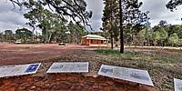
The Hills homestead stands adjacent to Wilpena Creek near Sliding Rock and The Gap, the only entrance to South Australia’s Wilpena Pound (Ikara — meeting place). Wilpena, believed to mean either bent fingers or cupped open hand from an Aboriginal dialect, and Pound—a holding pen for livestock—has a floor area of 83 square kilometres with walls exceeding 1000 metres. This natural bowl, that has a history dating back some 450 million years, was formed as rock was thrust upwards from the bed of a prehistoric sea.
The Hill family farmed the leased land from 1899 to 1914 when severe flooding ended their struggle against nature’s unforgiving might. Now restored, the homestead is part of the rugged and beautiful Flinders Ranges National Park.
Sound by audiochap on Freesound.
Location
Australia - New Zealand / Australia
Lat: 32° 33' 48" S
Long: 138° 33' 59" E
Precision is: Medium. Nearby, but not to the last decimal.
Equipment
Nikon D80
 Tap or click the zoom icon in the bottom right corner of the picture to switch between in-page and fullscreen view