
Cold War Nike Missile Integrated Fire Control System
Sandy Hook, New Jersey, USA
September 18, 2011, 12:32 pm

Loading panorama viewer ...
Configuring ...
© 2011 Brian Richards, All Rights Reserved.
Caption
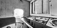
In 1954 Fort Hancock became home to Nike Site NY-56, one of a series of Nike missile sites that formed a circle around New York City. Nike Site NY-56 included the missile Launcher Area (LA) and the Integrated Fire Control (IFC) radar site where the Nike missiles were controlled and guided from. These two areas were located about one mile from each other.From 1954 until 1974, Nike Site NY-56 operated secretly as a last line of defense against a nuclear attack by Soviet Union bombers. Local residents were often aware that there were missiles behind the fences but very few knew that they were armed with nuclear warheads. Even today some residents find it "chilling" to learn that they lived so close.
More details at the Ft. Hancock Nike Accociation.
Multimedia virtual tour of the site.
Equipment
Nikon D300, Nikkor 10.5mm, Nodal Ninaj 3 MkII + D16 rotator
 Tap or click the zoom icon in the bottom right corner of the picture to switch between in-page and fullscreen view