
Antonio Victor Garcia-Serrano, PhD
Castellar d'Elx
Elche (Alicante), Spain
September 22, 2011, 08:25 CET

Loading panorama viewer ...
Configuring ...
© 2011 Antonio Victor Garcia-Serrano, PhD, All Rights Reserved.
Caption
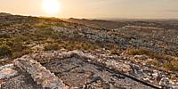
On my way back from taking the forgotten places event back in June 2010 I met Pascual Martinez, a local hiker who told me about some historic castle ruins on top of a nearby hill, El Castellar de la Morera. These were completely unknown to me at that time and he was then very kind to walk me there and show me the place. I have, since then, done some research about it and wanted to go back to this quiet and beautiful location to admire the morning lights and try documenting this site in 360º.This pano has then been captured at El Castellar d'Elx. The spanish word 'castellar' is defined as 'a plot where there is or there was a castle'. In this particular case this plot is located at a hill in Elche´s Sierra.
On the top of this hill you can find the remains of and ancient fortified settlement with roots that go back to prehistoric times. This archaeological site is also thought to be the ruins of the arabic IX century medina of Al-'Askar, a word meaning 'the camp'.
The study of this site, which is currently under development, could also help shedding some light on the origins of the nearby medieval city of Ils, to be latter known as Elx (Elche).
References:
"El Castellar d'Elx: l'origen de la ciutat medieval" Temporary expo at MAHE -Museum of Archaeology and History of Elche. 1st October 2010 - 20th March 2011
http://castellarelx.blogspot.com/
Equipment
Canon 5D - Canon 15mm fe - f.11 at 1/125 +-2, ISO 100, RAW Nodalninja lens ring + Manfrotto tripod (about 2m)
Photoshop-PTGui-Photoshop
 Tap or click the zoom icon in the bottom right corner of the picture to switch between in-page and fullscreen view