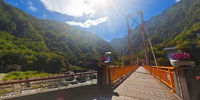

Tienhsiang Pudu Bridge, 天祥 普渡橋
Xiulin Township, Hualien County, Taiwan, 花蓮縣秀林鄉
September 18, 2010, 01:49 UTC (09:49 TPE)

Loading panorama viewer ...
Configuring ...
© 2010 Walker Young, All Rights Reserved.
Caption
Tienhsiang (天祥) is a large river terrace recreational area in Taroko National Park and it also a very beautiful location and important transfer post along the Central Cross Island Highway (中部橫貫公路). <The Central Cross-Island Highway or Provincial Highway No.8 is one of three highway systems that connect the west coast with the east of Taiwan.>Between Tienhsiang Tunnel (天祥隧道) and Zhihui Bridge (稚暉橋) You may walk through the pedestrian bridge across the Liwu River (立霧溪) to Siangde Temple (祥德寺). The pedestrian bridge name is "Pudu"(普渡), That means "Universal Salvation". So, sometime when we are standing at the crossroads, a good decision will be salvation our souls~ ;-)
Location
Lat: 24° 10' 55.19" N
Long: 121° 29' 45.23" E
Elevation: 466.211
Precision is: High. Pinpoints the exact spot.
Equipment
Canon EOS 5DII + 8mm/f8 fisheye
 Tap or click the zoom icon in the bottom right corner of the picture to switch between in-page and fullscreen view