
Chicago Portage • The Waterway West
The SW edge of Chicago, Lyons, Illinois, USA
September 23, 2010, 11:15 am local time

Loading panorama viewer ...
Configuring ...
© 2010 Victor Zaveduk,
Some Rights Reserved.

Caption
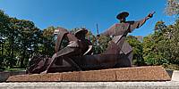
The Chicago Portage National Historic site marks the western end of the trail that was, up until the late 1840s, the connection between the Great Lakes and the Mississippi River. From here, a small creek once drained the semi-permanent "Mud Lake" into the Des Plaines River. Mud Lake stretched northeast to a sub-continental divide formed after the end of the last ice age and the retreat of the glaciers. From there, a short portage across open prairie provided access to the Chicago River and Lake Michigan. This portage served as the key to unlocking the water route between the North Atlantic and Eastern Seaboard, through the St. Lawrence and the Great Lakes, and the Mississippi River drainage system, the great "water highway" to the American inland, the west and the Gulf of Mexico.American Indian tribes from across the region converged in this area via a network of land and water trails making it an important crossroads for both trade and travel. In September of 1673, local Indians brought the French explorers Father Jacques Marquette and Louis Jolliet to this portage as they were returning from their journey of discovery along the Mississippi. It is Jolliet and Marquette, along with an Indian guide, who are depicted dragging a canoe through the shallows of Mud Lake in Ferdinand Rebechini's steel sculpture erected at the historical site in 1989.
Jolliet was inspired by the relatively short crossing to remark that "it would only be necessary to cut a canal through half a league of prairie (approximately two miles) to go in a bark by easy navigation from Lake Erie to the Gulf of Mexico." This geographic fact would ultimately lead to the creation of the City of Chicago and its importance as a crossroads of trade from across the country.
The Illinois and Michigan canal, completed in 1848 marked the end of the Chicago Portage. Mud Lake has long since vanished, the water drained and the land developed along with much of the surrounding region. But this bit of forested parkland remains much as it was, a connection to the past and to those who crossed paths here. You can learn more about the Chicago Portage by visiting the website of the Friends of the Chicago Portage.
Location
Lat: 41° 48' 19.1" N
Long: 88° 49' 10.6" W
Elevation: 600
Precision is: High. Pinpoints the exact spot.
Equipment
This panorama was created using a Nikon D90 camera equipped with a Nikkor 10.5mm fisheye lens, mounted on a Nodal Ninja 3 spherical bracket atop a Manfrotto 055MF4 tripod. Images were stitched using PTGui Pro. Additional post-processing in Photoshop CS4
 Tap or click the zoom icon in the bottom right corner of the picture to switch between in-page and fullscreen view