
BC Ferries Terminal
Swartz Bay (Victoria, British Columbia) Canada
September 18, 2010, 16:30 PST

Loading panorama viewer ...
Configuring ...
© 2010 Uri Cogan, All Rights Reserved.
Caption
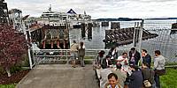
BC Ferries are our "highways" that link the many islands of the British Columbia coast among themselves and the mainland. The terminal at Swartz Bay, just North of Victoria, is one of several that serve as "crossroads" between the Gulf Islands, Vancouver Island and the mainland.
BC Ferries: http://www.bcferries.com
Uri's Home Page: http://www.uricogan.com
Location
USA-Canada / Canada-British Columbia
Lat: 48° 41' 17.76" N
Long: 124° 25' 35.76" W
Precision is: High. Pinpoints the exact spot.
Equipment
Nikon D700, Nikkor 10.5mm lens, Giotto Tripod with Nodal Ninja pano head.Software: PTGui, Adobe Photoshop CS5, Pano2VR.
 Tap or click the zoom icon in the bottom right corner of the picture to switch between in-page and fullscreen view