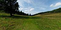

Crossing Trails
Hüttenwasen, Black Forest, Germany
September 23, 2010, 11:54 local time

Loading panorama viewer ...
Configuring ...
© 2010 Reinhard Schmolze, All Rights Reserved.
Caption
Two hiking trails show on a meadow high up in the Black Forest, close to the Feldberg, the highest mountain in the area.
Location
Lat: 47° 53' 4.31" N
Long: 7° 59' 54" E
Elevation: 1231m
Precision is: High. Pinpoints the exact spot.
Equipment
Pentax K200, Pentax 10-17mm, Philopod, PTGui
 Tap or click the zoom icon in the bottom right corner of the picture to switch between in-page and fullscreen view