

Loading panorama viewer ...
Configuring ...
© 2010 Ralph Greene, All Rights Reserved.
Caption
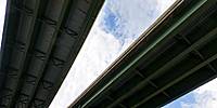
Because it is intersected by several major highways, Paramus, New Jersey, has become one of the largest shopping destinations in the United States. It is home to five malls and hundreds of stores. Pictured here, is the intersection where Route 4 crosses Route 17. In 1999 the original cloverleaf intersection, built in 1932, was upgraded with the addition of two flyover ramps (seen directly above). The highways are unusually empty this morning because Paramus has strict “blue laws” preventing most stores from being open on Sundays.
Location
Lat: 40° 55' 15" N
Long: 75° 5' 22.41" W
Precision is: Medium. Nearby, but not to the last decimal.
Equipment
Nikon D300, Nikkor 10.5mm lens. 360 Precision Atome head, PTGui, Photoshop CS5.
 Tap or click the zoom icon in the bottom right corner of the picture to switch between in-page and fullscreen view