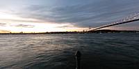

The Bosphorus (Bogazici) Bridge
Uskudar, Istanbul, Turkey
September 19, 2010, 7:22 pm (local time)

Loading panorama viewer ...
Configuring ...
© 2010 Nurcan Azaz, All Rights Reserved.
Caption
This panorama was taken on the Uskudar coast of the Asia continent in Istanbul. The Bosphorus (the strait) is one of the most important waterways in the world. It connects the Black sea to the Marmara sea.
The Bosphorus (Bogazici) Bridge connects the continents of Asia and Europe. It was built in 1973 and was the 4th longest suspension bridge in the world when its construction was finished.
The Bosphorus straight and the Bosphorus bridge exemplify a strategic crossroad.
Click here to see the print panoramas.
Location
Lat: 41° 2' 24.35" N
Long: 29° 2' 8.26" E
Elevation: 20 ft
Precision is: High. Pinpoints the exact spot.
Equipment
Photographed with my Canon A640 and Nikon FC-E9 fisheye lens, mounted on a bophoto pano bracket for Nikon FC-E9, stitched in PTGui, edited in Adobe Photoshop 7.0.
 Tap or click the zoom icon in the bottom right corner of the picture to switch between in-page and fullscreen view