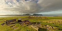

Stromness
The Western Entrance to Scapa Flow, Stromness, Orkney Islands, Scotland, UK
September 26, 2010, 08:15-08:19 UTC

Loading panorama viewer ...
Configuring ...
© 2010 John Leith,
Some Rights Reserved.

Caption
This is the Citadel Viewpoint in Stromness. It overlooks the western entrance to Scapa Flow and represents many crossroads.Stromness is the place where the ships of the Hudson's Bay Company took on water and their final supplies before sailing to Canada. Many young men (and some women) from Orkney decided not to follow their families into farming but made the big decision to go to the "Norwast" instead. Some made a new life in Canada and didn't come back, others returned with tales of adventure and more money than they left with.
Another crossroads event was in 1917, the German High Seas Fleet were anchored in Scapa Flow whilst peace was negotiated. Rather than let the ships fall into enemy hands if the negotiations failed, their crews scuttled them.
On a personal level Stromness is where I went to school and discovered electronics, so I changed direction and instead of becoming a farmer like my father, I went to work with electronics and computers.
Equipment
Canon EOS 500D, Velbon Tripod, Panosaurus
 Tap or click the zoom icon in the bottom right corner of the picture to switch between in-page and fullscreen view