
Lin's Mill Aqueduct
near Ratho, West Lothian, Scotland, UK
September 18, 2010, 13:36 local, 12:36 U

Loading panorama viewer ...
Configuring ...
© 2010 James Gentles, All Rights Reserved.
Caption
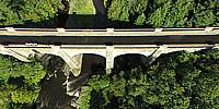
Maybe I didn't read the brief properly? It's more of a waterway flyover with 75ft separating the River Almond from the Union Canal. Completed in 1822 this is the smallest of three Aqueducts on the canal, but possibly the most spectacular located in a deep ravine.Interestingly enough the water is "connected." Overflow from the canal can drain into the river through the gate on the near-side of the aqueduct. The canal can be "topped up" from the river via a 3-mile-long supply feeder (some running underground) which appears to join the canal at the right (east) end of the aqueduct. Being 3 miles long allows the river to be >75ft higher, so again gravity is used!
The canal was built to take coal for heating into Edinburgh and horse manure out of Edinburgh. From an engineering perspective it represents the peak of canal technology, being one of the last canals to be built in the UK. Commercially the railways which arrived in the 1840s meant it never really made money.
The canal was abandoned in the 1960s, but re-opened exactly 10 years ago (September, 2000) as part of a regeneration project to make this "green corridor" live again.
Location
Lat: 55° 55' 12.72" N
Long: 4° 27' 1.68" W
Elevation: 72m + 50m
Precision is: Unknown / Undeclared.
Equipment
Nikon 8400 with FC-E9 Lens. Homemade camera cradle/rig, triggered by a
gentLED
intervalometer. Suspended below a Dan Leigh Cruiser R8 kite with an 8ft/2.5m span.This technique produces two hemispheres, and a different workflow in PTGui from the classic ground pano technique. This results in lower resolution BUT impossible angles!
See the rig, how Kite Aerial Photography is achieved, and the workflow.
Behind the scene : how this panorama was made
This panorama was taken using Kite Aerial Photography (KAP). Whilst more "hassle" to shoot, I hope you agree that the effect can be stunning. I have shot rectalinear at this location several times, and it offers an interesting subject for KAP. As you look at the Aqueduct the field over your left shoulder offers an ideal launch site for the kite.Once high in the sky the kite becomes stable enough to attach the camera that weighs 1.4Kg (3lbs). Always a nervous time as the fisheye lens has no protection should it touch the ground.
Letting out more line and the kite and camera climb higher, and I walked from the field actually onto the Aqueduct (You can just see me in shot). The camera automatically took around 120 images, every few seconds, rather than me as operator "taking" the picture. After the shoot the best image is chosen for the "down" hemisphere. A "stock" sky was added using the non standard workflow KAP employs.
Hopefully you like the results!
 Tap or click the zoom icon in the bottom right corner of the picture to switch between in-page and fullscreen view