
Loess Sunken Lane
Kaiserstuhl, Rhine Valley, Southwest Corner of Germany
September 26, 2010, 10:56 local time

Loading panorama viewer ...
Configuring ...
© 2010 Erik Krause, All Rights Reserved.
Caption
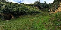
The Kaiserstuhl is a very fertile hill in the middle of the Rhine Valley. On the slopes of the former volcano loess was deposited during the Ice Age, making it an ideal region for wine growing.Loess sticks together but doesn't form something like stone. In the old lanes going steep up the vineyards loess was loosened by carriages and washed away by rain over and over again. Located near Bickensohl (part of Vogtsburg) the biggest depth of this sunken lane is 15m. The loess walls are rich biotopes now, giving home to wild bees and other insects as well as many cave breeding birds like f.e Bee-eaters.
Location
Lat: 48° 4' 39.79" N
Long: 7° 39' 1.27" E
Elevation: 294
Precision is: High. Pinpoints the exact spot.
Equipment
EOS 5DII, Zenitar 16mm, PTGui Pro, Photoshop
 Tap or click the zoom icon in the bottom right corner of the picture to switch between in-page and fullscreen view