
Arrival — Holbox Mexico, Part 1
Holbox, Quintana Roo, Mexico
September 18, 2010, 12:36 pm Central Texas Time (UT -6)

Loading panorama viewer ...
Configuring ...
© 2010 Dave Albright, All Rights Reserved.
Caption
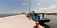
Isla Holbox (pronounced HOL-bush) most of the year is a small fishing town with an estimated 1,500 permanent residents. This island is located on the Northern edge of the Yucatan Peninsula. Holbox in Mayan means "Black Hole." The descendants of the original 8 families still reside there today. The locals are Mestizo, a mixture of Spanish European [possibly 19th Century 1520-1820 Caribbean Pirates] and Indian ancestry (Amerindians) not Mayan. Visitors typically find quiet turquoise waters and crystal white beaches. Tourist season is June through early September when the population is reported to increase 6,000 people. We arrived in September, 2010, to find very few tourists. Tourist season was finished. There are virtually no cars or trucks. The favorite mode of transport are electric golf carts which substitute for taxis. The main attraction is snorkeling with 30+ foot-long (10m) whale sharks. The largest living fish species, Whale Sharks are filter feeders that feed on plankton in the summer.
It was a 2 1/2 hour hot trip from Cancun. Ahhh! Now to find a cold beer and take a few panoramas. Our crossroads starts with our personal arrival after a 30 minute ferry trip at the Isla Holbox dock.
Location
Lat: 21° 31' 19.09" N
Long: 88° 23' 41.05" W
Elevation: Elev 0 feet (0 m) above Mean Sea Level
Precision is: High. Pinpoints the exact spot.
Equipment
Canon 500D (T1i), Sigma 8 f/3.5, Slik Monopod, Fanotec Nodal Ninja Ultimate R1 Ring Mount Pano Head , 4 +1z Raw images, Adobe Raw Converter 6, Adobe Photoshop CS5, PTGui 8.3.10, Pano2VR 2.3.4
 Tap or click the zoom icon in the bottom right corner of the picture to switch between in-page and fullscreen view