
Bubbles on the Crossroads
South Para River, Humbug Scrub, South Australia
September 19, 2010, 11:00 am

Loading panorama viewer ...
Configuring ...
© 2010 Chas Adlard, All Rights Reserved.
Caption
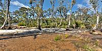
Bubbles on the CrossroadsThe winter of 2010 saw an end to a six-year drought. Widespread rain filled Adelaide’s dams and reservoirs and gave South Australian farmers a reason, once more, to smile. While rain was very welcome it also gave concern that those inhabitants in the low lands closer to the coast may be threatened by flood.
The South Para Reservoir only needed a little more rain for the inevitable overflow to occur. On the floodway below, water had already washed across this meeting place of river and road – a crossroad waiting to be breached…
sound by acclivity
Location
Australia - New Zealand / Australia
Lat: 35° 41' 54" S
Long: 138° 48' 54" E
Precision is: Low. Intentionally hazy, due to privacy concerns.
Equipment
Nikon D80
 Tap or click the zoom icon in the bottom right corner of the picture to switch between in-page and fullscreen view