
Where the Heck is a Crossroad?
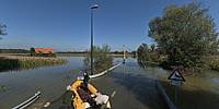
Ljubljansko barje, Lipe, Slovenia
September 21, 2010, 12:46 CEST

Loading panorama viewer ...
Configuring ...
© 2010 Boštjan Burger, All Rights Reserved.
Caption
The heavy rain began on Friday, September 17th, and continued until the next Sunday. Before the rain there was a Red Alarm for flood warnings. And it really happened: the largest flood in the written history of Slovenia and the largest flood in the area of Ljubljana Marsh which is situated on the southern suburbia of Ljubljana. The whole country was flooded and in some areas the water raised up to 6 m high. And imagine—Slovenia is not a flat country but with dynamic and high relief. The panorama shows the crossroad nearby the Lipe settlement, which is about 3 km south of Ljubljana and 7 km from the centre of the capital. The only possible transport was a boat and at the time this panorama was shot it was 3 days later and the area is still flooded.
Location
Lat: 45° 59' 23.63" N
Long: 14° 27' 11.31" E
Elevation: 297 m
Precision is: High. Pinpoints the exact spot.
Equipment
Nikon D200, Sigma 8mm, pole & remote
 Tap or click the zoom icon in the bottom right corner of the picture to switch between in-page and fullscreen view