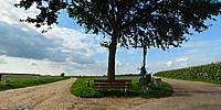

Oak Tree
Between Wahlwiller and Eys, Netherlands
September 18, 2010, about 16:30 h local time

Loading panorama viewer ...
Configuring ...
© 2010 Bert Knops,
Some Rights Reserved.

Caption
The tree here is a familiar landmark in this region. There used to stand a big old oak, but that's been replaced by this smaller one.You can see 6 roads leading up to this 5 way crossing (2 of them join in the distance). Going clockwise, starting at the bench, two roads go to Eys, one to Baneheide, one to Nyswiller, one to Wahlwiller and one goes in the direction of Wittem.
This is also the top of the Kruisberg, a climb in the Amstel Gold Race, a classic cycle race.
Equipment
Camera: Panasonic DMC-LX3, LA4 adapter, LW46 wide-angle lens.
Shooting: handheld, 15 bracketed shots, 30 pictures.
Software: Hugin, Enblend, Enfuse, PTEditor, GIMP.
 Tap or click the zoom icon in the bottom right corner of the picture to switch between in-page and fullscreen view