
When the Sun Goes...
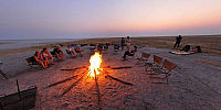
Makgadikgadi pans - One Tree Island, Botswana
September, 19th 2008 - 06:55 local

Loading panorama viewer ...
Configuring ...
© 2008 Rolf Ris, All Rights Reserved.
Caption
When the sun is gone, every color will change to gray or black and white.
The little group of campers starts the campfire and brings back some colors to the area.
Location
Lat: 21° 28' 11.31" S
Long: 25° 21' 50.46" E
Elevation: 2986 ft
Precision is: Medium. Nearby, but not to the last decimal.
Equipment
Nikon D300 - Nikkor 10,5 (fullframe fisheye) Monopod with NodalNinja 3
PtGuiMac - Photoshop - CubicConverter
Quicktime Pro
Macintosh Powerbook 17" - 1,67 GHz OSX 10.5
 Tap or click the zoom icon in the bottom right corner of the picture to switch between in-page and fullscreen view