
The colors swirl ...
Los Angeles, California, USA
September 19, 2008, 4:04 pm (9-20-08, 12:04 am GMT )

Loading panorama viewer ...
Configuring ...
© 2008 Pat Swovelin, All Rights Reserved.
Caption
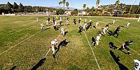
Ribét Academy vs. The Webb Schools (Claremont campus) at RibétColors swirl in a blur of motion as the teams charge across the field in a desperate and ultimately unsuccessful effort to get away from the defense and score a touchdown.
Nice tackle, Preston!
Even though it's "only" High School football it is inherently dangerous and proved itself tragically so. The week before this game another school in the same league, Boron High School, had a player make a tackle with his head down that gave him irreversible brain damage. His parents were faced with the unthinkable and 4 days after the game made the decision to take him off of life-support. He was a sophomore and only 16-years-old with his whole life before him.
RIP Vinnie Rodriguez
Location
Lat: 34° 6' 47.38" N
Long: 119° 15' 31.49" W
Elevation: 393 feet
Precision is: High. Pinpoints the exact spot.
Equipment
Canon 450D (Digital Rebel XSi), Sigma 8mm f3.5 lens, Nodal Ninja 5 panohead, custom made 12' monopod, Yong Nuo YN-128 wireless remote control, ISO 100, f5.6, 1/400 second exposure, Canon RAW, Photoshop CS3, PTGui Pro 8.0.2, Pano2VR 2.1 beta3, NBNC, PDL
 Tap or click the zoom icon in the bottom right corner of the picture to switch between in-page and fullscreen view