

Loading panorama viewer ...
Configuring ...
© 2008 Edward Bigelow, All Rights Reserved.
Caption
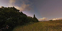
Past sundown on Maui. Vog (volcanic smog) and burning sugar cane put particles and moisture into the air, creating an apparent atmospheric corona over the setting sun. Opposite, evening clouds bring the first rain in weeks and blocking sunlight from the sky-borne particles, casting a momentary blue shadow that changes to pink as the clouds move away.Up slope stands the mount (pu`u) of Kauhikoa, or "covered in Koa." Nearly all Koa was unsustainably timbered in the mid-18th century, much of it exported to the southwest of the United States for use as ties on the Santa Fe railroad. The mount is now covered with Blue Gum (Eucalyptus,) brought from Australia in 1865.
For 15 months in 1944-1945 this was a rest, recreation and training area for the US Marine 4th Division. A sprawling camp was built where over 15,000 troops lived between battles fought in the South Pacific at Kwajalein Atoll, the Marshall Islands, the Mariana islands of Saipan and Tinean, and at Iwo Jima.
Some marines took local women for occasional walks through the forest, and the site gained the nickname "Giggle Hill."
www.ebigfoto.com
Location
Lat: 20° 54' 26.75" N
Long: 157° 20' 17.36" W
Elevation: 222 Meters
Precision is: Medium. Nearby, but not to the last decimal.
Equipment
Hardware: Nikon D40x, Peleng 8mm, NN3, Tripod.Camera Settings: ISO 100, 1/2 sec, f/8.0
Software: Adobe DNG Converter 4.6, PTGui 7.5, Photoshop 9.0, Pano2qtvr 1.6.2pro.
 Tap or click the zoom icon in the bottom right corner of the picture to switch between in-page and fullscreen view