
"Teruel Also Exists"
Peracense, Teruel, Spain
September 22, 2007 - 11:00 UTC (12:00 local time)

Loading panorama viewer ...
Configuring ...
© 2007 Paco Lorente, All Rights Reserved.
Caption
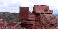
This is a well known slogan in Spain. It tells about one of his least inhabited provinces, Teruel (Aragón), that with a population only of 140.000 and 14.700 sq.km. has a density of only 9,6 inhabitant/sq.km.In this case we are talking about a place in a forgotten corner of this province, a small village named Peracense, about his environment and his castle.
This area has several villages of less than 100 inhabitants each one, they are located near of iron mines of Sierra Menera, that were actives from 1900, exporting even iron to England and United States, but closed in the 80s by crisis of 70s. Since then, economy and population were down.
Today, restoration of Peracense castle, his tourist promotion, and the growing rural and active tourism in Spain, is starting to give a new light to the sustenance of this villages: public investment, employment, restaurants, some tourist acommodation, etc.
Also, mining has left an old abandoned railway that now is been converted to a green way (Ojos Negros green way). It will allow cycling from here (from a height of 1.100 meters) down to the Mediterranean sea (Sagunto city), over 180km., the largest green railway in Spain, ... and his next opportunity.
About the castle:
Built around 1300 as a military castle because his position as frontier post between old Castilla and Aragón kingdoms. His walls are made of red sandstone (Buntsandstein) as his environment, with a special color that change along the day.
This panorama was made on the top of north side. In this point there is no wall, it is not necessary, there is a striking chasm.
More panoramas about this area of Teruel http://www.panorama360.es/teruel
More information:
http://www.castillosdearagon.es (castles of Aragón)
http://www.viasverdes-ffe.com/languages/programme_english.htm (greenways)
http://www.albarracin.org (a near tourist place)
http://www.turismodearagon.com/web/en/home.asp (tourism)
Equipment
Nikon F80, Sigma fisheye 15mm, handheld, Velvia film, PTGui, PanoCube.
"Teruel también existe" [español]
Este es un conocido slogan en España utilizado en la promoción de esta provincia, Teruel (Aragón). Una de las provincias con menos población de España, que con una población de solo 140.000 habitantes posee 14.700 km. cuadrados, es decir, una densidad de solo 9,6 habitantes/km2.En concreto en esta imagen nos referimos a un olvidado rincón de esta provincia, al pueblo de Peracense, a su castillo y a su entorno.
Esta zona tiene varios pueblos de menos de 100 habitantes cada uno. Están situados en las cercanias de las minas de hierro de Sierra Menera, que estuvieron activas desde 1900 y que fueron cerradas en los años 80 tras la crisis de la siderurgía de los años 70. Desde entonces la economía y la población irremediablemente se redujeron.
Hoy, la restauración del castillo de Peracense (que esperemos que obtenga finalmente los fondos deseados), su promoción turística y el continuo crecimiento del turismo rural y activo en España, dan una nueva luz al mantenimiento de estos pueblos: inversión pública, empleo asociado a esta, algún restaurante, albergue, etc.
También, la minería ha dejado una línea de ferrocarril abandonada que actualmente se está convirtiendo en vía verde (Vía Verde de Ojos Negros). Cuando finalice permitirá pedalear desde aquí (a unos 1.100 metros de altura) hasta el mar Mediterraneo (la ciudad de Sagunto), unos 180km., convirtiéndose de ese modo en la vía verde de mayor longitud de España, y en una nueva oportunidad para esta zona.
Sobre el castillo:
Construido entorno al año 1.300, su papel fué de castillo militar a causa de su caracter de frontera entre los reinos de Aragón y Castilla. Sus muros son de arenisca roja (Buntsandstein), tal como lo es su entorno, lo que le da un color especial y sorprendente que cambia con la luz del día.
Este panorama se realizó sobre una roca en la cara norte. En este punto no existe muralla ya que no es necesario, el propio desnivel natural impide cualquier acceso.
Más panoramas sobre esta zona de Teruel en http://www.panorama360.es/teruel
Mas información:
http://www.castillosdearagon.es
http://www.viasverdes-ffe.com (vías verdes)
http://www.albarracin.org (una zona turística cercana)
http://www.turismodearagon.com (turismo en la región)
 Tap or click the zoom icon in the bottom right corner of the picture to switch between in-page and fullscreen view