

Loading panorama viewer ...
Configuring ...
© 2007 Michel Thoby, All Rights Reserved.
Caption
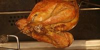
Lunch is ready!
Equipment
Canon EOS 20D + Zoom Canon 24-85 mm @ 85 mmManfrotto 190B + Tungsten projector.
Scholtes FE856 / 220V / 50Hz
QTVRAS 1.01 MacOS 9 (classic)
Français
Episode 1260°C: Le déjeûner est prêt!
 Tap or click the zoom icon in the bottom right corner of the picture to switch between in-page and fullscreen view