
Running the Bay Trail
Shimada Friendship Park, Richmond, California, USA
23 September 2007 - 09:57 PDT (UTC -7)

Loading panorama viewer ...
Configuring ...
© 2007 Landis Bennett, All Rights Reserved.
Caption
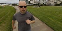
Back in high school I used to run track and cross-country. I wasn't particularly good at either but my mother insisted that I participate in a sport and football sure wasn't too appealing to someone my size. Running it was.After high school I pretty much stopped running. I recently took it up again and have quite enjoyed it. I would feel better physically when I would go to the gym but I never really looked forward to it. A friend who works near my house asked if anyone in the area wanted to take up running with him. I volunteered knowing that I feel better after exercising even if I don't enjoy it. After the first two weeks it turns out that not only do I feel better, I actually look forward to this form of exercise.
Of course, being able to run along the San Francisco Bay Trail which runs right by my house is a big help. Depending on the weather a trail user will get views of up to three of our bridges including the Golden Gate and Bay Bridge as well as San Francisco and several of the islands. The temperature is generally perfect for running, including on this gloomy looking day.
Running is definitely a good way to sustain my physical being, and it's pretty good for the mind too. Now if only I could lose a couple pounds...
Shimada Friendship Park commemorates the city of Richmond's sister-city status with Shimada, Japan. If you'd like to see what it looks like on a day with blue skies see Don Bain's panorama on his Virtual Guidebooks site. Another panorama of the Bay Trail can be seen on Kat Bennett's WWP contribution for Transportation
360Geographics - Panoramas from all over North America of tourist destinations and places off the beaten path.
Location
Lat: 37° 54' 28.36" N
Long: 123° 21' 41.17" W
Precision is: High. Pinpoints the exact spot.
Equipment
Hardware: Nikon D200, Nikkor 10.5mm Lens, Kaidan QuickPan III SphericalSoftware: PTGui/Mac, Photoshop CS2, CubicConverter
 Tap or click the zoom icon in the bottom right corner of the picture to switch between in-page and fullscreen view