
Social Sustenance
Marina Bay, Richmond, California, USA
23 September 2007 - 15:55 PDT (UTC -7)

Loading panorama viewer ...
Configuring ...
© 2007 Kat Bennett, All Rights Reserved.
Caption
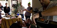
On September 23, the equinox, Landis and I chose to go to a Progressive Party around our condo complex for Social Sustenance. We feel it is really important to get to know your mates next door or in the next building. Several of these folks have taken care of our cat when we've been gone or just checked our house when they thought something was amiss, and nothing was at the time, which was nice.We moved into the complex over a year and half ago and found ourselves at what I like to call the party block. We formed a league and get together for these parties several times a year. We find five of our neighbors willing to share their home for an hour and travel around to each where we find a cocktail or wine beverage with hors d'oeuvres. Since nobody is driving we all get to meander together around the property, 25 acres (10.1 hectares), from place to place.
Here we are at our second stop of the afternoon, we started at 4:00, hosted by Bernie and Ahi. Bernie is pictured the most, he is the host after all, social butterfly and man with the vino, and Ahi is blurred in the passthrough beyond the table. There are several people who are blurred currently and then became blurrier as the afternoon progressed.
This was also Landis' and my anniversary. At first and last stop our friends lifted a toast to our two years together. It was really special and kind, they even chipped in for a cake, which surprised us since we had brought one to share with all of them. This day was truly fun and wonderful to share. The friendships we've formed here have been great sustenance to us.
Location
Lat: 37° 54' 47.45" N
Long: 123° 21' 26.96" W
Precision is: High. Pinpoints the exact spot.
Equipment
Hardware: Nikon D200, Nikkor 10.5mm Lens, Corybant West Electric Nodal MountSoftware: PTGui/Mac, Photoshop CS2, CubicConverter
 Tap or click the zoom icon in the bottom right corner of the picture to switch between in-page and fullscreen view