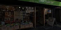

Oxfam Bookshop
Frankfurt am Main, Germany
September 22, 2007 - 11:42 UTC (12:42 local time)

Loading panorama viewer ...
Configuring ...
© 2007 Jürgen Matern, All Rights Reserved.
Caption
Theme
I interpreted the term "sustenance" as something which someone has to do to earn a living.You can see a bookshop in the panorama. The people who work there don't work there to earn money for themselves, but to make money for someone else. Every Oxfam shop is operated by volunteers. Even the books are contributions to the organization.
With the revenues earned in the shops, the organization supports various projects all over the world, to support people in sustaining their lives.
Making Of
The shooting was done with a virtual tripod (without using a bubble level). The virtual tripod is also called a Philopod.With a fisheye attached to my camera, four pictures easily cover 360°. But due to the lighting conditions I took three exposures at each direction. Fortunately I was able to extract a well exposed picture out of the middle exposure.
I took two additional pictures for the zenith and nadir. Luckily the stitching went pretty well and only little retouching was necessary at zenith and nadir. Therefore I didn't have to use these pictures.
Links
- The site of Oxfam Germany
- The contact page of the featured bookshop
- The site of Oxfam International
Equipment
- Camera: Konica Minolta Dynax 7D
- Lens: Sigma 8mm fisheye
- Mounting: Hand held using a Philopod (without using a bubble level)
- Software: Panotools, PTGui, Smartblend, PSCS3, Pano2QTVR
- Pictures: 4 pictures @ 90°, zenith and nadir retouched manually
 Tap or click the zoom icon in the bottom right corner of the picture to switch between in-page and fullscreen view