
Hydropower Plant Birsfelden
Birsfelden, just upstream of Basel, Switzerland
September 22, 2007 (around 17:30 local time)

Loading panorama viewer ...
Configuring ...
© 2007 Claudia Betschart,
Some Rights Reserved.

Caption
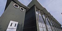
Sustenance - the first expression that came to my mind in this context was "sustainable energy". So I went to the hydroelectric power plant in Birsfelden to take my panorama. It is located just a little upstream of the city of Basel, in the river Rhine. The four turbines located in the buildings with the zigzag roof produce 17% of the electricity used in the Greater Basel Region.
Due to it's geographical location Switzerland is in the privileged situation to produce 60% of the electricity by hydropower plants. Hydroelectricity has many advantages over other energy sources (no release of CO2, no waste). But as every energy source, it also has it's down-sides and impact on nature. Just mentioning one example, the weir crossing the river blocks any traffic across this line, including migration of fish. To sustain the migration of fish a fish-ladder has been installed. The road on top of the weir is open for walking and bicycles, sustaining a connection across the river.
Location
Lat: 47° 33' 37.67" N
Long: 7° 37' 31.87" E
Elevation: 255 m
Precision is: High. Pinpoints the exact spot.
Equipment
Hardware: Nikon FM3 on Nodal Ninja SPH-1i, very cheap low-weight tripod, Sigma 8mm fisheye lens, slide film scanned on Nikon Coolscan 5000 Software: PTGui, Adobe Photoshop CS2, Pano2QTVR
 Tap or click the zoom icon in the bottom right corner of the picture to switch between in-page and fullscreen view