
Close to the Limit of Sustenance
Schniderli-Hof, Hofsgrund, Black Forest, Germany
September, 22th 2007, 15:05 CEST

Loading panorama viewer ...
Configuring ...
© 2007 Carsten T. Rees, All Rights Reserved.
Caption
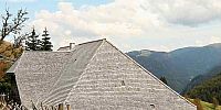
The house in the panorama is called the "Schniderli-Hof. It is a typical "Schauinsland-House". The Schauinsland is one of the highest mountains in the Black Forest (elevation 1284 m above sea level) and is located south-east of Freiburg.Since the Schauinsland is situated at the western rim of the Black Forest, weather coming from the West will hit the mountainside very hard. Thus in wintertime, the snow-level can be very high – more than 2 meters. In the spring of 1936 five English boy scouts died only one mile away from the Schniderli-Hof, when their school class lost its way in a blizzard.
The house is built to stand against the hard wheather. It is comparatively small and is leaning against the slope of the mountain. The roof-ridge is running parallel to the contour line (isohypse) of the slope. In the panorama you can see the side of the house facing west. This is the so called "weather side" of the house and the roof covers this entire side of the house. All but one of the entrances are located on the side of the house facing east – the so called "good weather side". One entrance of the house leads directly from the slope into the top level of the house. The food for the cattle enters the house via this entrance. When feeding the cattle, the hay only needs to be dropped through holes in the floor.
The Schniderli-Hof was built in 1593 by Wolf Schneller. In 1807 Trudpert Schneider (Schneider: German word for taylor) owned the house. In the Alemannian dialect a little taylor is called Schniderli (pronounced like shneederlee).
Nowadays the house is a museum. When visiting the museum, you can learn how hard life used to be in these kind of houses in the Black Forest. Living in these houses meant living close to the limit of sustenance.
In the small version of the panorama you can see strong moiré effects on the roof of the house. These are due to a very special tiling of the roof. The roofing tiles on this house are very small . Every single one of the tiles is crafted by hand from a piece of wood.
Location
Lat: 47° 54' 25.72" N
Long: 7° 53' 58.82" E
Elevation: 1043m
Precision is: High. Pinpoints the exact spot.
Equipment
Canon EOS 5D, Sigma 12-24 mm, Manfrotto 303SPH + 338, Realviz Stitcher Unlimited
 Tap or click the zoom icon in the bottom right corner of the picture to switch between in-page and fullscreen view