

Loading panorama viewer ...
Configuring ...
© 2006 Mike Runge, All Rights Reserved.
Caption
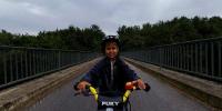
Transportation with kids is always a bit complicated. We all were happy, when the buggy was gone and Nikhil (our son) was able to move on his own with a 'Like a Bike' (bicycle without pedals). Meanwhile he is 4 years old, he got a bicycle on his birthday and he loves to take a tour with the whole family and friends to a restaurant called "Auermuehle" ~10-15 kilometers from our home (with a large playground outside). Although he learned to ride his bike, he's not able to do the whole tour completely on his own. At some point, he needs assistance and so we bought this famous thing called "Trail Gator" to temporary connect our bikes for tandem processing. He kick's the pedal and I steer the handle bar ;-)
This rainy sunday was the only chance for us to take a photo for the WWP. Because of the unfriendly weather I took an unfriendly place for shooting too - on top of a bridge over the autobahn. It was cold, rainy and very, very noisy, but my son loved to do his very best for the WWP photo :-)
Location
Lat: 51° 19' 4.5" N
Long: 6° 53' 52.42" E
Elevation: 390
Precision is: High. Pinpoints the exact spot.
Equipment
Hardware:Pentax *istD, Sigma 8mm (4 shots), selfmade panohead mounted on 'Trail Gator', a small boy called Nikhil to assist me
Software:
Pentax PhotoLaboratory 3, Hugin 0.61, Autopano-Sift, Enblend 2.3, Pano2QTVR, The Gimp
 Tap or click the zoom icon in the bottom right corner of the picture to switch between in-page and fullscreen view