
Heading for Planes and Trains
Long Distance Train Station at the Airport, Frankfurt am Main, Germany
September 22, 2006 - 16:55 UTC (18:55 local time)

Loading panorama viewer ...
Configuring ...
© 2006 Jürgen Matern, All Rights Reserved.
Caption
The location:
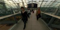
The long-distance train station at the airport of Frankfurt/Main is one of 5.400 train stations in Germany. It's operated by the German railroad company Deutsche Bahn. The station went into service 1999. It measures approx. 700 m. in length, 50 m. in width and 45 m. in height. The station is divided into two main levels. The trains operate on the lower level, the passengers can change tracks and head to the airport via the upper level (distribution level). The large glass dome, which spans the distribution level is clearly visible in the panorama.Via a network of ICE high-speed trains, the station/airport is reachable within 11 min. from Frankfurt main station, within 30 min. from Mannheim, within 54 min. from Cologne main station and within 1 h 13 min. from Stuttgart. Directly at the exit of the train station you'll find check-in counters of the airport. As a special service of Lufthansa, you can check-in your flight luggage in Stuttgart, or Cologne.
The start of the building project of the Airrail-building is scheduled for November 2006. By 2009 the building will cover the 30 cm. reinforced concrete plate, which currently serves as roof for most of the train station. For a view of the plate and the glass dome be sure to check out the location with Google Earth. The glass dome will be integrated in the Airrail-building.
Making Of:
As the shooting location is the middle of a heavy used bridge I didn't use a tripod. Instead I used a virtual tripod, which is also called a Philopod. I just started shooting, and when the passenger volume over the bridge grew too large I was able to step aside.With a fisheye attached to my camera, four pictures cover 360°. But as I wanted to show some passengers I took 22 shots and afterwards I selected the four shots, with the most passengers captured.
As the roof contains lots of details I took two additional pictures for the zenith. One of the pictures was used in the final panorama. Due to the use of a Philopod as "tripod" it's footprint was not visible and therefore the nadir was retouched manually.
Equipment
- Camera: Konica Minolta Dynax 7D
- Lens: Sigma 8mm fisheye
- Mounting: Hand held using a Philopod (without using a bubble level)
- Software: Panotools, PTGui, Smartblend, PSCS2, Pano2QTVR
- Pictures: 4 pictures @ 90°, zenith, nadir retouched by hand
 Tap or click the zoom icon in the bottom right corner of the picture to switch between in-page and fullscreen view