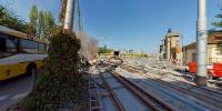

Tramway Line 15
Loewentor Crossing, North of Stuttgart, Germany
from September 21 to 24, 2006 - around 15.30 local time every day

Loading panorama viewer ...
Configuring ...
© 2006 Josh von Staudach,
Some Rights Reserved.

Caption
This panorama covers three days of various situations at the same spot ... Two workers are casting incandescent steel into a frame. The new rails of the tramway line 15 are laid in Nordbahnhof street -- an important public transport across the city of Stuttgart. It stretches between tv tower and the prison in Stammheim. Besides that you can see a lot of other transport units and facilities in this panorama: tram, buses, lorries, a digger, cars, a bicycle ... the bridge, the crossroad ... the condensation trail of an airplane ... even the ladder on the ground helps to bring persons to other places. Shame: only a ship is missing -- or can you spot one? (Don't miss to zoom out completely for an incredible viewing angle of 160 degrees)***
Dieses Panorama faengt 3 Tage mit verschiedenen Situation am selben Ort ein ... Zwei Arbeiter giessen gluehenden Stahl in eine Gussform. Die neuen Gleise fuer die Strassenbahn Linie 15 werden in der Nordbahnhofstrasse verlegt - eine wichtige Nahverkehrsverbindung durch die Stadt Stuttgart. Die Linie reicht vom Fernsehturm bis zum Gefaengnis im Vorort Stammheim. Nebenbei kann man viele andere Transportgeraete im Panorama wiederfinden: Strassenbahn, Busse, Lastwagen, einen Bagger, Autos, ein Fahrrad ... die Bruecke, die Kreuzung ... der Kondensstreifen eines Flugzeugs ... sogar die Leiter auf dem Boden hilft Menschen an andere Orte zu gelangen. Schade: nur ein Schiff fehlt - oder kannst du eines finden? (Nicht vergessen ganz auszuzoomen um einen verblueffenden Blickwinkel von 160 Grad zu bestaunen)
Equipment
Canon 30D, Sigma 8 mm
 Tap or click the zoom icon in the bottom right corner of the picture to switch between in-page and fullscreen view