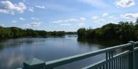

Mississippi River at Highway 610
Brooklyn Park, Minnesota, USA
September 24, 2006 - 19:00 UTC (13:00 Central)

Loading panorama viewer ...
Configuring ...
© 2006 Grant Hermanson, All Rights Reserved.
Caption
Between the cities of Brooklyn Park and Coon Rapids and the counties of Hennepin and Anoka, State Highway 610 crosses the Mississippi River. This is a little over a mile down-river of some of my previous entries at the Coon Rapid Dam(March, 2004 and June, 2005), and near a related panorama I took for my own site a few years ago. This has transportation elements of the road and cars, the river, the rollerbladers who just happened to be passing by, and also a few con-trails from airplanes in the sky.
Equipment
Nikon CoolPix 8700, Kaidan Quickpan III Spherical
 Tap or click the zoom icon in the bottom right corner of the picture to switch between in-page and fullscreen view