
Maria Fumaça
Campinas, SP, Brasil
September 20, 2006 - 13:40 UTC (10:40 local time)

Loading panorama viewer ...
Configuring ...
© 2006 Giancarlo Miragliotta, All Rights Reserved.
Caption
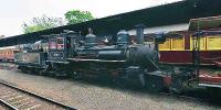
This is the Anhumas Station in Campinas City, São Paulo State, Brazil. "Maria Fumaça" (Steam Train) came from the end of century XIX and it is still functioning thanks for the restoration and maintenance works by Brazilian Railroad Preservation Association, "ABPF". Rail tracks, stations and locomotives had been brought from England since 1958. The coffee production was the great responsible for the maintenance of the railroads. Due to the coffee's decline, the railroads had been slowly abandoned and road transportation, with better cost/benefit rate, has initiated its era.
Esta é a estação Anhumas em Campinas São Paulo, Brasil. A Maria Fumaça é do final do século XIX e ainda está em funcionamento graças ao trabalho de restauração e manutenção da Associação Brasileira de Preservação Ferroviária, "ABPF". Trilhos, estações, locomotivas, foram trazidos da Inglaterra a partir de 1958. A época do café foi a grande responsável pela manutenção das ferrovias. Com o declinio do café, as ferrovias foram aos poucos sendo abandonadas e o tranporte rodoviário, com uma melhor relação custo/benefício, iniciou a sua era.
Location
Lat: 23° 52' 31.47" S
Long: 48° 2' 47.63" W
Elevation: 2046 ft
Precision is: High. Pinpoints the exact spot.
Equipment
Nikon F2A Photomatic, Nikkor 16mm f/2.8D AF Fisheye, self-made panohead and tripod. Fuji Superia ISO 100.
 Tap or click the zoom icon in the bottom right corner of the picture to switch between in-page and fullscreen view