
Merida Airport - Aeropuerto de Mérida
Mérida, Venezuela
September 24, 10:00 local time

Loading panorama viewer ...
Configuring ...
© 2006 Gerardo A. Sanchez, All Rights Reserved.
Caption
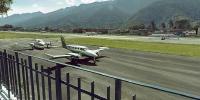
Merida AirportOne of the most useful modes of transportation is the airplane. It lets us move quickly between distant places in a safe and efficient way. This panoramic view shows Alberto Carnevali Airport in the city of Mérida, Venezuela. Opened in 1956, this airport used to be outside the city, but urban growth in the 1960s and 70s has left it surrounded by houses and buildings on all sides (airport aerial view). The city is framed by two mountain chains. The largest, on the south, includes (Pico Bolívar), which reaches 4978 mts above sea level. It is the highest point in Venezuela.
The airport runway, 1640 mts long and 60 mts wide, is on a slight west-east grade and serves only daytime domestic flights. Nevertheless, traffic is heavy, mostly between Mérida and Caracas, the Venezuelan capital. Mérida has one of the country's most beautiful settings and attracts visitors from around the world.
The view in the opposite direction shows a small swimming pool, at the "Colegio de Ingenieros" headquarters. Swimming is the natural form of transportation for many animals. It is a healthy and enjoyable exercise for humans as well!
Aeropuerto de Mérida
Uno de los medios de transporte más utilizados en la actualidad es el avión. Este nos permite movernos rápidamente entre lugares muy distantes de una manera efectiva y muy segura. En esta panorámica Ud. está viendo la pista del aeropuerto Alberto Carnevali de la ciudad de Mérida , en Venezuela. Inaugurado en el año de 1956, este aeropuerto estaba ubicado en las afueras de la ciudad, pero el rápido crecimiento urbano durante los años 60 y 70, pronto lo dejó completamente rodeado de viviendas y edificios por sus cuatro costados (ver foto aérea del aeropuerto). Dos grandes cadenas de montañas se encuentran a su alrededor, del lado sur está la Sierra Nevada con su pico más alto, (el Pico Bolívar), a 4978 mtsm.
La pista del aeropuerto es de aproximadamente 1640 metros de largo por 60 de ancho y con una pequeña pendiente en sentido este-oeste, solo se utiliza para vuelos internos y no posee radioayuda ni luz de balizaje. Sin embargo por esta terminal se mueven constantemente gran número de pasajeros principalmente hacia Caracas, la capital del país.
Si Ud. mira en la otra dirección verá la piscina de la sede del Colegio de Ingenieros un pequeño lugar para diversión y esparcimiento ubicado a pocos metros de la pista del aeropuerto.
El nado es utilizado por muchas especies de animales para su transporte diario bien sea migratorios, en búsqueda de alimento o simplemente por diversión. Para nosotros los humanos, aunque no es nuestro medio natural de movimiento, la natación quizás nos transporte hacia una vida más ¡saludable y divertida!
Equipment
Nikon D50, Sigma 8mm, home made panohead. Software: PanoTools, Adobe Photoshop CS2, Pano2QTVR
 Tap or click the zoom icon in the bottom right corner of the picture to switch between in-page and fullscreen view