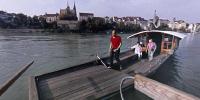

Münsterfähre (Minster Ferry)
Basel, Switzerland
Saturday, September 24, 2006 (around 10 am local time)

Loading panorama viewer ...
Configuring ...
© 2006 Claudia Betschart,
Some Rights Reserved.

Caption
The border city of Basel is situated on the river Rhine in the northwestern corner of Switzerland, meeting France and Germany. The place has been inhabited since prehistoric times and due to the river always had some importance for transportation. The ports of Basel still are one of Switzerland’s main entry and exit point for goods, and the Rhine is defined to be an international waterway up to the Mittlere Brücke in Basel, connecting the inland with the ocean. Beside trade, Basel also has cultural significance (oldest University in Switzerland, founded in 1460) and is known for its industry (today above all chemical and pharmaceutical industry). The oldest bridge crossing the Rhine in Basel was constructed in 1226 at the place of today’s Mittlere Brücke (“middle bridge”, on the right side of the cathedral in the pano). It was still the only bridge in 1847, when the first ferry was constructed just a little upstream of today’s Münsterfähre (“minster ferry”). In 1877 the Münsterfähre started operation, shortly before the oldest ferry had to be given up due to the construction of the Wettsteinbrücke (Wettstein Bridge, on the left side of the cathedral in the pano).
There are still four ferries in daily operation. They are all hanging on cables and are moving powered just by the current.
Here you find more information on the ferries http://www.faehri.ch/engl.html and the city http://www.basel.ch/en/basel/home
Location
Lat: 47° 33' 29" N
Long: 7° 35' 40" E
Elevation: 245
Precision is: High. Pinpoints the exact spot.
Equipment
Hardware: Nikon FM3, Sigma 8mm fisheye lens, Nodal Ninja panohead, slide film scanned on Polaroid Sprint Scan 35Plus Software: PTGui, Adobe Photoshop
 Tap or click the zoom icon in the bottom right corner of the picture to switch between in-page and fullscreen view